The history of Tower Hamlets
The East End of London and the London Borough of Tower Hamlets bear the evidence of a dramatic history of wealth, poverty, total war and the area’s survival against the odds.
|
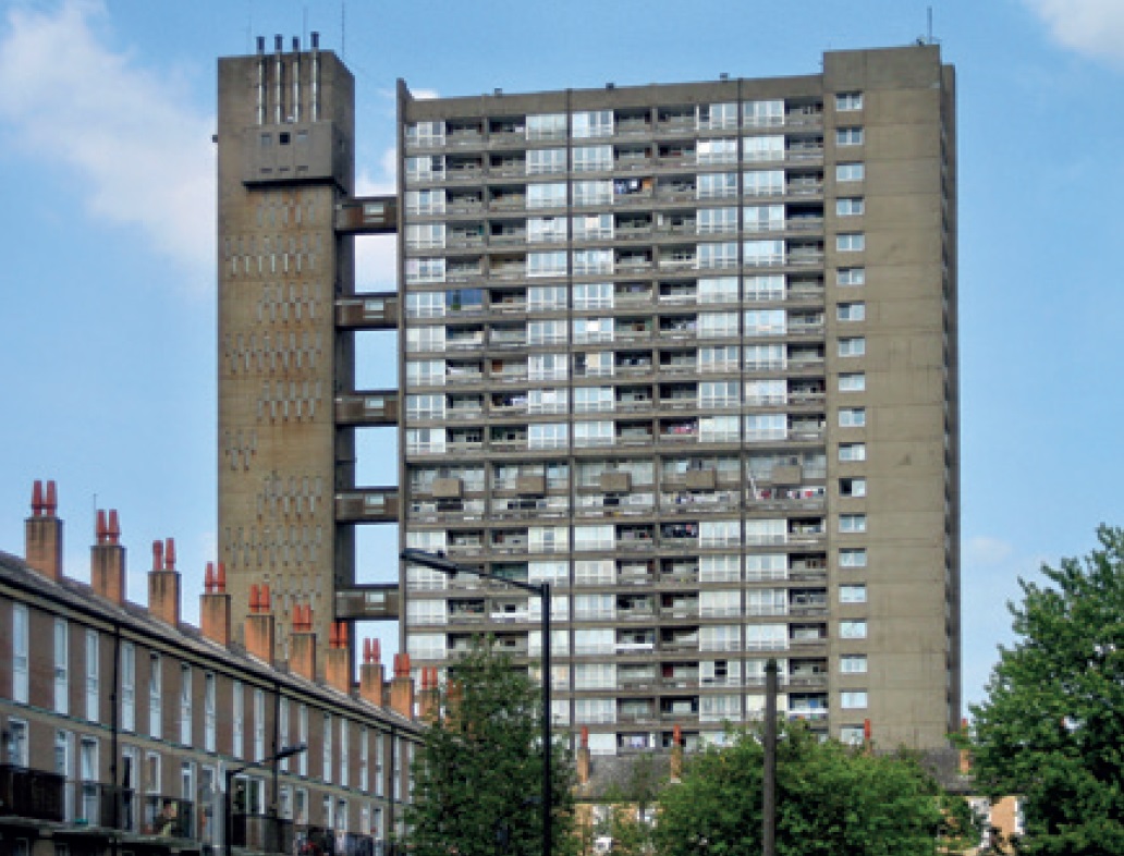
| Erno Goldfinger’s Balfron Tower on the Brownfield Estate in Poplar was built by the Greater London Council in 1965–67. (Photo: SebastianF, Wikimedia). |
Towns and cities near the coasts and estuaries of Britain and mainland Europe have been subject to attacks by fireships, artillery weapons and bombing from the air. It was easy for the enemy to approach from the sea with little warning. London suffered in both major wars of the 20th century and, although I could tell a similar story for Portsmouth, Plymouth or many other places, it is the London Borough of Tower Hamlets that interests me most.
The East End of London has been no stranger to disaster. The Thames broke its banks in 1660, Samuel Pepys recording serious flooding in Westminster and worse in Limehouse, and a major fire in 1794 laid waste to large stretches of the East End, followed in the next century by the loss from fire of riverside warehouses. The Commercial Road, which acts as an East–West spine of early-19th century development, was created as a result of the 1794 fire that had laid waste to buildings there, giving rise to present-day classical squares along its length, such as Arbour Square and Albert Gardens. These Victorian areas and the Edwardian growth that followed came under attack from Zeppelin airships and early Gotha bomber planes, starting in Tower Hamlets with a raid in 1915. Such random killing would be repeated many times a generation later in the second world war.
The raids of 1914–1918 warned Britain of what might follow in a new war conducted from the sky. Electronic surveillance was developed as a first line of defence, followed by such inner lines as barrage balloons and anti-aircraft fire. Civilian populations were given the chance to endure the raids in shelters. A war of bluff and counterbluff was conducted in secret by the British and Germans. Dummy airfields and make-believe factories were constructed. The ultimate deception was the use of the newly excavated tunnel to extend the Underground’s Central Line from the City to the Essex suburbs. The unfinished tunnels, some located in Tower Hamlets, were used at Bethnal Green as an air-raid shelter capable of holding thousands of eastenders. A further 4,000 workers were employed round the clock in shifts farther along the line from Stratford onwards, in a vast factory making and assembling aircraft equipment in the security of an underground location invisible from the air.
Bombing began soon after the outbreak of the war. A total of 257 lives were lost in London in the year from 3 September 1939 to 6 September 1940. In the remaining months of 1940, 13,000 people were killed in London in the Blitz, and a total of nearly 30,000 in the whole of the second world war. About 70,000 buildings were demolished or damaged beyond repair in London’s core boroughs and a further more than 100,000 required major repair. These were not only peoples’ homes and workplaces, but also character areas and monuments.
There were no conservation areas or listed buildings in the 1940s. Only ancient monuments (such as the Tower of London in Tower Hamlets), old churches and major secular pre-Queen-Anne buildings were recognised as being of significance.
Dropping bombs in patterns proved highly effective in destroying the docks on both sides of the Thames and other strategic sites. Heavy losses of Tower Hamlets housing were suffered on the western bank of the River Lea. Nicholas Hawksmoor’s St George in the East, whose construction had begun in 1715, was gutted by fire. Reconstructed and listed Grade I (awarded in 1950), it is the centrepiece of a Tower Hamlets conservation area. An article by John (later Sir John) Summerson (1904–92) in the Architectural Review in 1941 recorded the serious damage to the church. The article was the first of a series of notices in the press about wartime losses of heritage, which led to the beginnings of listing, as architectural historians set about the task of reckoning the cost to the nation’s past being paid due to war. Concerns extended to unease in the same circles about Bomber Command’s own raids being conducted in Europe as the war swung in favour of the Allied side.
We are able to make some sense of the patterns of the bombings shown on the London County Council maps, but not for the attacks by rocket that followed. The first V1 rockets were unleashed only a few days after the Normandy Landings in June 1944 and the V2 rockets later that year. The trials for the flying bombs and rockets had been secretly monitored for a year at least by British security and intelligence agencies, revealing the essential unreliability of these weapons, which could deliver only small amounts of explosives, compared to air-dropped bombs. It was the random nature of these rocket attacks and the difficulty of intercepting them that caused the greatest concern.
V2 rockets came out of the sky without warning. The terror at home did not end until their launch sites in Europe had been overwhelmed by the army, and the production and transport of the rockets had been disrupted. A final V2 fell in Stepney, Tower Hamlets, in March 1945, in the last bitter weeks of the war in Europe. A block of flats was demolished and 125 residents died. Altogether Tower Hamlets suffered about 60 of these rocket hits, including some in the Thames or on its banks, and three near Tower Bridge. The Nazi regime is said to have regarded the Victorian bridge as the most important target in London. Many rockets overshot and the non-strategic area of South Kensington took several hits, including to the Natural History Museum, which narrowly escaped destruction. The walls of the Victoria and Albert Museum opposite still carry the marks left by flying bomb debris.
With the clearance of millions of tons of debris, the aftermath of bombing left whole areas devoid of buildings. Beyond these, depots of reclaimed bricks stretched across acres. The flavour and appearance of London in the immediate post-war era is vividly caught in the 1949 Ealing Comedy film ‘Passport to Pimlico’, many of its scenes having been shot at bombsites or in the surviving back streets of the capital.
The reconstruction of popular housing in the post-war era is another story. Those who wish to visit Tower Hamlets are directed to Poplar, where a number of estates of houses and their shopping centres are to be seen, with new churches in the modernist style. Following the rapid rebuilding, a second phase of rehousing saw the construction of tower blocks of flats, including some that have been listed, such as Erno Goldfinger’s Balfron Tower of 1965. In the meanwhile, many inhabitants had left such central areas when docks and industries were closing, to settle in Essex or Hertfordshire, or to occupy new homes in new towns such as Stevenage and Basildon.
When London’s population fell in the 1960s, the East End’s half-empty streets and boarded-up houses were the scenes of gangland violence, and the old pubs that stood on nearly every street corner took on a louche and edgy ambience that brought in hordes of pleasure-seekers who found pubs in more respectable locations to be too bland or genteel. These East End pubs have since become the object of strenuous efforts in Tower Hamlets planning policy to retain their fabric, even if they are not open as licensed premises. Some of them, both closed and open (such as the Grapes, 76 Narrow Street), are listed.
Initial listing surveys began from 1947–49 against this backdrop of recent destruction, as Carole Ryan recorded in her article in Context in November 2009. The surveys were essentially a record of survival, rather than the nomination of buildings to be given special treatment aimed at preservation, as listing has since become. Conservation areas (of which Tower Hamlets has 58) followed the Civic Amenities Act 1967. During this period of economic decline many late-Georgian streets and squares fell into decay. A new programme of listing was launched in the 1970s to secure their future. Miles of terraces and numerous squares in areas such as Bow Road and Tredegar Square were placed on the lists. With a subsequent reversal of decline, they have today become some of London’s finest displays of neoclassical domestic architecture and town planning.
With the area’s abundant stock of industrial buildings, listing was also a means of preserving warehouses, factories such as the Bryant and May match factory, and some of the old dock basins next to the Thames. These former industrial sites have been successfully transformed into mixed areas of housing, commercial, leisure and office use, with new fabric built next to sites of historic value. Typical locations are around the former St Katherine’s Dock near the Tower and along the winding path of Narrow Street, downstream to the east. Dock basins have become yacht marinas or canal-boat moorings.
Touring Tower Hamlets in the 21st century will astonish those who do not know the East End and will gratify others who knew it during the years of its agony. Great architecture, such as its many fine churches, some by Nicholas Hawksmoor, is seen against a background of diversity and a widely ranging housing stock from the most humble to the grandest elegance. The borough lies between the City of London and Canary Wharf.
Of the monuments in its streets, one of the most poignant is to the deaths of the 18 children killed at Upper North Street School in Poplar in 1917, by the first daylight bombing attack on London by fixed-wing aircraft. The memorial is listed and forms the core of the St Matthias Conservation Area. Another memorial is to the 173 victims of the Bethnal Green Underground disaster of 1943, when a stampede broke out on the stairs leading down to the air-raid shelter in the disused Central Line station. The worst single civilian loss of life in the UK during the war, it was hushed-up at the time but eventually received a memorial erected near to the station in 2017.
Further reading
- Castle, Ian (2015) The First Blitz: bombing London in the first world war, Osprey Publishing
- Jones, RV (1978 and 2009) Most Secret War: British scientific intelligence 1939–1945, Hamish Hamilton
- Ward, Laurence (2015) LCC Bomb Damage Maps, 1939–1945, Thames and Hudson
This article originally appeared as ‘From Armageddon to listing’ in the Institute of Historic Building Conservation’s (IHBC’s) Context 176, published in June 2023. It was written by Graham Tite, who worked at the London Borough of Tower Hamlets Council in 2022 and 2023.
--Institute of Historic Building Conservation
Related articles on Designing Buildings
IHBC NewsBlog
SAVE celebrates 50 years of campaigning 1975-2025
SAVE Britain’s Heritage has announced events across the country to celebrate bringing new life to remarkable buildings.
IHBC Annual School 2025 - Shrewsbury 12-14 June
Themed Heritage in Context – Value: Plan: Change, join in-person or online.
200th Anniversary Celebration of the Modern Railway Planned
The Stockton & Darlington Railway opened on September 27, 1825.
Competence Framework Launched for Sustainability in the Built Environment
The Construction Industry Council (CIC) and the Edge have jointly published the framework.
Historic England Launches Wellbeing Strategy for Heritage
Whether through visiting, volunteering, learning or creative practice, engaging with heritage can strengthen confidence, resilience, hope and social connections.
National Trust for Canada’s Review of 2024
Great Saves & Worst Losses Highlighted
IHBC's SelfStarter Website Undergoes Refresh
New updates and resources for emerging conservation professionals.
‘Behind the Scenes’ podcast on St. Pauls Cathedral Published
Experience the inside track on one of the world’s best known places of worship and visitor attractions.
National Audit Office (NAO) says Government building maintenance backlog is at least £49 billion
The public spending watchdog will need to consider the best way to manage its assets to bring property condition to a satisfactory level.
IHBC Publishes C182 focused on Heating and Ventilation
The latest issue of Context explores sustainable heating for listed buildings and more.


