Radial city plan
|
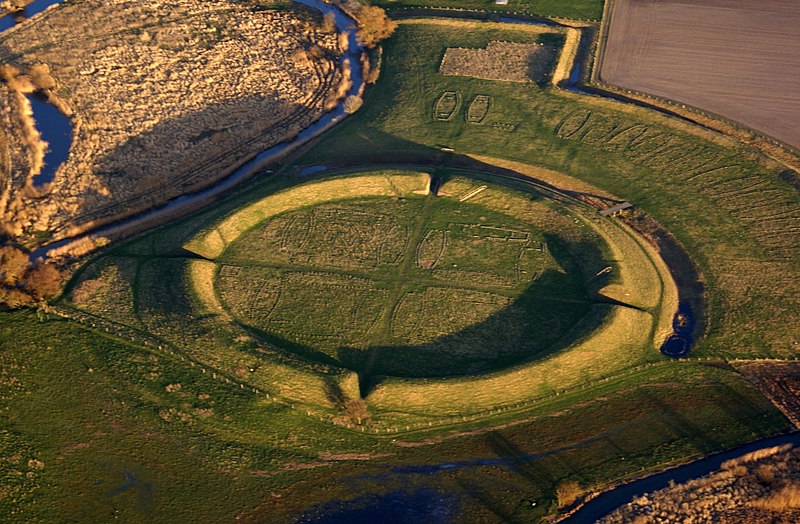
| Early concentric cities in Europe often came in the form of settlements built within castle walls. Trelleborg is one of these ancient sites, located in Denmark near Slagelse on the isle of Seeland. |
Contents |
[edit] Introduction
A radial city plan (also referred to as a radial urban plan or radial concentric city plan) is an urban planning approach, that, instead of using a traditional rectangular grid, is based on a series of concentric circles. An important community or commercial building (or collection of buildings) is sometimes placed at its centre. Roads radiate out from the centre linkin ring roads.
Some cities are completely radial, while others only incorporate this approach in certain neighbourhoods or areas of the city. This can be due to limitations such as topography, zoning, geography, existing buildings and roads and so on.
[edit] History
Radial city planning goes back to ancient times. Early cultures used the circular configuration to bring together the community while keeping out invaders. One early European example of radial city planning is the Danish settlement of Trelleborg. Situated within a circular Viking castle, the city of more than 1,000 people was occupied from approximately 980 AD to 1050 AD.
[edit] Circleville, Ohio
The concentric circle city model was used in many parts of the world even before Trelleborg. Over the centuries, some cities that started with radial plans made the change to rectangular grids.
In the early 1800s, the US town of Circleville, Ohio was planned and built over prehistoric circular earthworks. The courthouse was placed in the centre of the town’s radial plan.
In just a few decades, the radial plan had become unpopular and was considered ‘peculiar’. At this point, a conscious decision was made to convert the town plan from circular to rectangular. By 1856, the city’s Circleville Squaring Company had successfully redeveloped the town to remove its radial past.

|
| This overhead map of the city of Circleville, in Pickaway County, Ohio, is from 1876 - after its concentric circle plan had been entirely replaced by a grid. The town kept its name despite the drastic change in its configuration. |
[edit] Circular garden cities
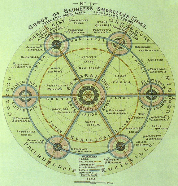
As early as 1820, the landscape architect John Claudius Loudon envisaged cities as concentric rings of buildings interspersed with open green areas. In the late 1800s, Sir Ebenezer Howard built on Loudon's idea by incorporating the radial approach into his proposed garden cities. As a self-sufficient combination of living space, industry, agriculture and leisure, Howard’s garden cities used concentric circles connected by radial roads. Parks and other open spaces would be placed in strategic areas to support the community.
Once capacity was reached in the original community, a new garden city could be built nearby. This would not only help to reduce overcrowding and slums, it would create community clusters that could be connected through public infrastructure.
|
| Sir Ebenezer Howard's idealised garden city incorporates concentric radial cities linked by railways and roads. |
[edit] Basic requirements of a radial city plan
The success of circular cities (like the garden cities developed by Howard) is based on essential factors, including:
- Geography - the natural geography of the site should be able to accommodate suitable outward growth.
- Topography - the land should be flat, open and free from drastic changes that could cause obstructions to development.
- Ideology - the developers, overseers and occupants should understand (and ideally embrace) the philosophy of a radial city plan and be prepared to adhere to the principles behind it - regardless of possible restrictions to economic development and growth.
[edit] Related articles on Designing Buildings Wiki
- Brasilia Syndrome.
- Collaboration needed to deliver national and regional transport strategies.
- Compact sustainable city.
- Densification.
- Garden cities.
- Garden communities and the historic environment.
- Garden suburb
- London Cycle Network.
- Piazza.
- The green belt and historic buildings
- Town and Country Planning Association TCPA
- Town planning.
- Urban design.
Featured articles and news
Gregor Harvie argues that AI is state-sanctioned theft of IP.
Many resources for visitors aswell as new features for members.
Using technology to empower communities
The Community data platform; capturing the DNA of a place and fostering participation, for better design.
Heat pump and wind turbine sound calculations for PDRs
MCS publish updated sound calculation standards for permitted development installations.
Homes England creates largest housing-led site in the North
Successful, 34 hectare land acquisition with the residential allocation now completed.
Scottish apprenticeship training proposals
General support although better accountability and transparency is sought.
The history of building regulations
A story of belated action in response to crisis.
Moisture, fire safety and emerging trends in living walls
How wet is your wall?
Current policy explained and newly published consultation by the UK and Welsh Governments.
British architecture 1919–39. Book review.
Conservation of listed prefabs in Moseley.
Energy industry calls for urgent reform.
Heritage staff wellbeing at work survey.
A five minute introduction.
50th Golden anniversary ECA Edmundson apprentice award
Showcasing the very best electrotechnical and engineering services for half a century.
Welsh government consults on HRBs and reg changes
Seeking feedback on a new regulatory regime and a broad range of issues.
CIOB Client Guide (2nd edition) March 2025
Free download covering statutory dutyholder roles under the Building Safety Act and much more.


