


Cartesian
Applied digital documentation In the historic environment, published on 19 March 2018 by Historic Scotland, defines cartesian as: ‘A coordinate system that assigns two (for 2D space) or three (for 3D space) numerical coordinates for a point.’
The Geospatial Glossary, published by the Geospatial Commission, and accessed on 17 September 2022, defines a cartesian coordinate system as: ‘A coordinate system that specifies each point uniquely in a plane by a set of numerical coordinates, which are the signed distances to the point from two fixed perpendicular oriented lines, measured in the same unit of length.’
[edit] Related articles on Designing Buildings
Featured articles and news
Open industry engagement survey seeks responses

Institutions and the importance of engagement.
National Retrofit Hub unveils new guide
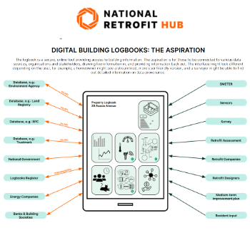
Digital Building Logbooks and Retrofit: An Introduction.
Top 50 firms awarded 52bn of projects in the last year

New engineering data shows.
Enhancing construction site reporting efficiency

Through digitisation and the digital revolution.
Noise in the built environment
BSRIA guide TG 20/2021.

17,000 people suffer conditions as a result of exposure to excessive noise at work.
Turning down the noise: Auditory health

A pervasive risk with far-reaching consequences.
Getting the most out of heat pumps and heating

How heat pumps work and how they work best.
Plumbing and heating for successful retrofit and renovation

Low temperature underfloor systems and heat pumps.
Cost-of-living crisis and home improvement plans

Starting on the right footing and top tips for projects.
Delays on construction projects

Types, mitigation and the acceleration of works.

From Chaucer to Fawlty Towers.

Electrotechnical excellence, now open for entries.
Net zero electricity grids BSRIA guide NZG 5/2024
Outlining the changes needed to transition to net zero.
CIOB Global Student Challenge 2024

Universitas Indonesia wins for second year running.
ECA 2024 Apprentice of the Year Award

Entries open for submission until May 31.