


Site surveys
Site surveys are detailed studies carried out to supplement and verify site information provided by the client and site appraisals carried out by the consultant team.
They may begin with a simple walkover survey and then progress to more detailed surveys focusing on specific issues.
Site surveys might be carried out by members of the consultant team if they have the required skills, or might be commissioned from specialists. The consultant team should assess what surveys are required (generally after initial feasibility studies have been carried out), and request approval from the client to commission those surveys or carry them out themselves.
Site surveys might include:
- Existing buildings (including valuation, measured surveys, structural surveys, structural investigations, condition surveys, and demolition surveys).
- Geological and geotechnical.
- Topographical surveys, perhaps including laser scanning, Lidar or photogrammetry.
- Contamination.
- Ecological survey.
- Archaeological (see Archaeology).
- Traffic and transport.
- Local climate.
- Flood risk.
- Air quality.
- Acoustic.
- Photographic.
- Historic use.
- Boundary surveys.
- Structural surveys (including retained structures, underground structures and obstructions).
- Unexploded bomb survey.
- Railway and tunnel search.
- Asbestos and other hazardous materials surveys and registers.
- Fire hydrants.
- Telecommunications.
- Wireless networks and satellite reception.
- Electrical infrastructure and capacity.
- Gas network infrastructure and capacity.
- Foul sewers and drains infrastructure and capacity.
- Existing water supply infrastructure and capacity.
- Soil survey.
Wherever possible, any information prepared or obtained should be in a format which can be readily shared and used, and should be stored and named in a way consistent with the long-term project and operational needs.
[edit] Related articles on Designing Buildings
- 3D laser survey.
- Archaeology and construction.
- Building People.
- Building survey.
- Condition survey.
- Desk study.
- Development appraisal.
- Easements.
- Ecological survey.
- Environmental Impact Assessment.
- EWS1 forms not required for buildings without cladding.
- Ground conditions.
- Ground investigation.
- Interferometric synthetic aperture radar InSAR.
- Interview with Elly Ball, co-founder, Get Kids into Survey.
- Land surveying.
- Laser scanning.
- Levelling.
- Measurement of existing buildings.
- Pre-construction information.
- RICS publishes Land Measurement for Planning and Development Purposes.
- Site appraisals.
- Soil survey.
- Surveying instruments.
- Surveyor.
- Technical due diligence.
- Vendor survey.
- Walkover survey.
- What is a valuer?
Featured articles and news
Specifying rendered external wall insulation for fire safety

How to interrogate the evidence provided to the specifier.
The benefits of writing articles for your organisation

How to create a profile for your organisation and publish for free.
No Falls Week. The importance of safe working at height
![]()
What to expect and what is on offer to avoid accidents.
Scottish Government action to reach net-zero targets

Retrofit expert group highlight critical actions needed.

A forward thinking, inclusive global community of members.

From engineered product life-spans, to their extension.
Circular economy in the built environment

A brief description from 2021. Where are we now?
Mental Health Awareness Week with ABS

Architects Benevolent Society programme of activity.
CLC publishes domestic retrofit competency framework
Roadmap of Skills for net zero.

May 13-19: Moving more for our mental health.
Understanding is key to conservation.
Open industry engagement survey seeks responses

Institutions and the importance of engagement.
National Retrofit Hub unveils new guide
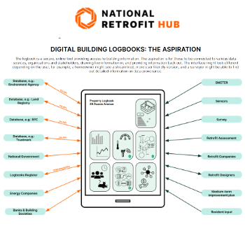
Digital Building Logbooks and Retrofit: An Introduction.
Enhancing construction site reporting efficiency

Through digitisation and the digital revolution.