


Preliminary site investigations
The term ‘desk study’ or ‘desktop study’ refers to a study that is carried out purely through research, rather than physical investigations, that is, it can be done sitting at a desk. Desktop studies can provide an initial understanding of a subject or situation, identify potential risks and inform the detail, scope and methodology of subsequent investigations.
On building design and construction projects, the term ‘desktop study’ is often used in relation to preliminary site investigations, referring to the process of gathering background information about site-specific characteristics that will need to be considered during planning, design and construction, or issues that may merit more detailed physical investigations, such as site surveys.
Local authorities often require that a desk study is carried out as part of the planning or building regulations approval process.
Approved Document C of the Building Regulations defines desk studies as, ‘A review of the historical, geological and environmental information about the site’ and describes it as being ‘essential’. Desk studies might also be carried out as the starting point for assessing site lines, local context (such as architectural character, landscape, and so on), archaeology (such as the risk of uncovering archaeological remains, unexploded bombs, and so on), rights of way and other easements, the likely presence of solid and liquid contaminants, site ecology, and so on.
A thorough desk study:
- Provides an initial understanding of the characteristics of an area or site.
- Provides early identification of site characteristics and potential risks so they can be more effectively managed.
- Informs the detail, scope and methodology of subsequent investigations.
- May help avoid undertaking unnecessary, expensive or intrusive investigations.
The most common sources of information that are researched as part of a desk study include:
OS maps, including historical maps can offer information about:
- Changes in potential landslide areas.
- Changes in topography, stream and river courses.
- Coastal erosion.
- Concealed mine shafts.
- Disused quarries and in-filled ponds.
- Drainage.
- Former uses of the site.
- Old clay, gravel and sand pits.
Geological maps can provide an indication of the likely ground conditions and whether, for instance, there is any risk of subsidence or shear.
Aerial photographic records and Google maps provide useful information that can help identify or confirm historical site usage, hidden foundations, changes of topography and river course, and so on.
Services records can help locate hidden services such as; electricity cables, drainage, telephone cables, and so on.
Existing client information may exist from previous investigations, estate record drawings, and so on.
Preliminary site investigations will typically be followed by more detailed physical investigations to assess areas where more information is required, or where there are particular concerns. For more information see: Site investigations.
[edit] Related articles on Designing Buildings
- Archaeology and construction.
- Building archaeology.
- Building survey.
- Development appraisal.
- Ground conditions.
- Insitu testing of soils.
- Laser scanning.
- Pre construction information.
- Site appraisal.
- Site investigation.
- Site investigation information.
- Site surveys.
- Soil report.
- Soil survey.
- Solid and liquid contaminants site risk assessments.
- Walkover survey.
Featured articles and news
The benefits of writing articles for your organisation

How to create a profile for your organisation and publish for free.
No Falls Week. The importance of safe working at height
![]()
What to expect and what is on offer to avoid accidents.
Scottish Government action to reach net-zero targets

Retrofit expert group highlight critical actions needed.

A forward thinking, inclusive global community of members.

From engineered product life-spans, to their extension.
Circular economy in the built environment

A brief description from 2021. Where are we now?
Mental Health Awareness Week with ABS
Architects Benevolent Society programme of activity.
CLC publishes domestic retrofit competency framework
Roadmap of Skills for net zero.
May 13-19: Moving more for our mental health.
Understanding is key to conservation.
Open industry engagement survey seeks responses

Institutions and the importance of engagement.
National Retrofit Hub unveils new guide
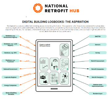
Digital Building Logbooks and Retrofit: An Introduction.
Enhancing construction site reporting efficiency

Through digitisation and the digital revolution.
Noise in the built environment
BSRIA guide TG 20/2021.

17,000 people suffer conditions as a result of exposure to excessive noise at work.
Turning down the noise: Auditory health

A pervasive risk with far-reaching consequences.
Getting the most out of heat pumps and heating

How heat pumps work and how they work best.

Electrotechnical excellence, now open for entries.