


File:Ordnance survey map 26 12.png
Size of this preview: 800 × 432 pixels
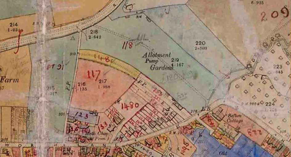
Ordnance Survey map 26.12 (Gloucestershire Archives D2428/3 with thanks also to Marin Bailey) shows Ryeworth Field allotment gardens, hereditament number 118, 4.2 acres (1.7 ha), valued at £500, and owned by Charlton Kings Urban District Council. Source: ‘Landownership in England in 1909’, in the Institute of Historic Building Conservation’s (IHBC’s) Context 171, published in March 2022, written by Anthea Jones, who was head of history and director of studies at Cheltenham Ladies’ College. Now retired, she is the author of several books on Gloucestershire history, most recently Johannes Kip: the Gloucestershire engravings. https://ihbconline.co.uk/cont_arch/?p=1218
File history
Click on a date/time to view the file as it appeared at that time.
| Date/Time | Thumbnail | Dimensions | User | Comment | |
|---|---|---|---|---|---|
| current | 06:33, 7 August 2022 | | 944 × 510 (851 KB) | Designing Buildings (Talk | contribs) | (Ordnance Survey map 26.12 (Gloucestershire Archives D2428/3 with thanks also to Marin Bailey) shows Ryeworth Field allotment gardens, hereditament number 118, 4.2 acres (1.7 ha), valued at £500, and owned by Charlton Kings Urban District Council. Source) |
- Edit this file using an external application (See the setup instructions for more information)
File usage
The following page links to this file:
BIM Directory
[edit] Building Information Modelling (BIM)
[edit] Information Requirements
Employer's Information Requirements (EIR)
Organisational Information Requirements (OIR)
Asset Information Requirements (AIR)
[edit] Information Models
Project Information Model (PIM)
[edit] Collaborative Practices
Industry Foundation Classes (IFC)