


File:InSARVolcano.jpg
No higher resolution available.
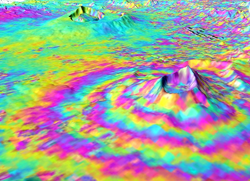
Envisat satellite, ESA, Wikimedia Commons, source: http://www.esa.int/spaceinimages/Images/2010/06/Volcanic_uplift Not for reuse. This Envisat Advanced Synthetic Aperture Radar interferogram over the Kenyan section of the Great Rift Valley shows small surface displacements that are not visible to the naked eye of the Longonot Volcano (front right). In the background is Suswa volcano, which was not deforming at this time. Using SAR Interferometry (InSAR), a group of scientists discovered that from 1997 2000 the volcanoes at Suswa and Menengai (not visible) subsided 2 5 cm, and between 2004 and 2006 the Longonot Volcano experienced uplift of around 9 cm (pictured). Interferogram images appear as rainbow-coloured interference patterns. A complete set of coloured bands, called 'fringes', represents ground movement relative to the spacecraft of half a wavelength, which is 2.8 cm in the case of Envisat's ASAR.
File history
Click on a date/time to view the file as it appeared at that time.
| Date/Time | Thumbnail | Dimensions | User | Comment | |
|---|---|---|---|---|---|
| current | 16:42, 19 March 2021 | | 800 × 581 (108 KB) | Editor (Talk | contribs) | (Envisat satellite, ESA, Wikimedia Commons, source: http://www.esa.int/spaceinimages/Images/2010/06/Volcanic_uplift Not for reuse. This Envisat Advanced Synthetic Aperture Radar interferogram over the Kenyan section of the Great Rift Valley shows small su) |
- Edit this file using an external application (See the setup instructions for more information)
File usage
The following page links to this file: